|
Home


|
| |
The lakes
The DRIMON Project is studying two large natural lakes on the Balkan, i.e. the Skadar and Prespa lakes. These lakes are shared between two or more countries, and they are both threatened by increased eutrophication due to human impacts. Since the DRIMON Project is a co-operation between Norwegian and Balkan researchers, a Norwegian lake is also included in the project, the Lake Vansjø in Eastern Norway.
Lake Prespa
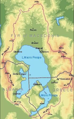
The Prespa Lake is shared between Albania, Macedonia and Greece. It is located at a higher point than any other large lake in the Balkans (853 m), and is covering an area of over 274 km2. Its maximum depth is 52.4 meter.
The lake does in fact comprise two lakes, the Macro and Micro Prespa. Water flows from the shallow Micro Prespa to Macro Prespa through a narrow channel. The DRIMON Project is monitoring the nutrient levels in the Macro Prespa, both on Albanian and Macedonian side.
The largest tributary to Lake Prespa is the Golema Reka, entering the lake from the Macedonian side. Its catchment area covers 231 km2, and the river drains through town of Resen, the largest settlement in the region, as well as several rural villages.
Two other tributaries are the Brajcinska and the Kranska, draining forested and agricultural areas in the eastern shores of the Prespa. These were monitored for nutrients and suspended matter in 2004 by the DRIMPOL Project, the results showed that the streams carry relatively low nutrient and particle loads, and in the DRIMON Project, the monitoring of tributaries is therefore focusing oom the Golema. Here, suspended solids and nutrient concentrations are monitored monthly during 2007. There is no main outlet stream, as underground streams and groundwater moves water from the Prespa to the lower-lying Lake Ohrid under the Galichica mountains.
Lake Prespa is rich in biodiversity, and supports a wide range of flora and fauna. Seventeen species of fish have been recorded, among them an endemic variety, the Barbus plebejus cyclolepis, and wild trout. There are also 11 types of amphibians, 22 reptiles, 45 mammal species, and over 260 species of birds. The Prespa is famous for its rare colonies of Dalmatian Pelicans (Pelecanus crispus and Pelacanus onocrotalus).
The entire area is therefore of international importance according to the Ramsar Convention, and in 2002 the Prime Ministers of Albania, Greece and Macedonia jointly declared the establishment of Prespa Park, a new protected area including the Prespa Lake and surrounding forests. This was the first transboundary ecologically protected area in the Balkans.
|
|
 |
| |
Lake Prespa is shared between three countries - Macedonia, Albania and Greece. |
| |
|
Lake Shkoder/Skadar
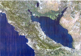
Lake Shkoder/Skadar is shared between Montenegro and Albania, and has the largest surface area of all lakes on the Balkan Peninsula, varying between 353 km2 in dry periods and 500 km2 in wet periods. The drainage area of the lake is about 5,500 km2. The lake is relatively shallow, with a minimum depth of 5-9 meters and a maximum depth of 60. The lake lies only 5 meter above sea level.
The most important tributary is the Moraca River, which enters the lake from the north west, and drains large parts of Montenegro including the capital Podgorica. This river, with its two tributaries, Zeta and Cijevna/Cemi, contributes 62 percent of the lake’s water. Another important river on the Montenegrian side is the Crnevica, which drains the south western parts of Montenegro. On the Albanian side, the most interesting tributary in terms of discharge of nutrients and sediments is believed to be the River Kiri. The DRIMON Project monitors these rivers for nutrient and sediment loads. In addition to these rivers, several groundwater springs both in and near the lake complicates the hydrology and therefore the water balance calculations of this lake.
Unlike Prespa, Lake Skadar has a defined outlet in the Bojana/Buna River, which runs from the eastern shore of Lake Skadar to the Adriatic Sea. The Buna converges with the Drini River just a few hundred meters downstream of the outlet, and sometimes the outflow from the lake is impeded due to increased flow in the Drini. This is one major reason why the surface area of the lake varies considerably. This impediment is partly dependent on rain, and therefore happens frequently during December to February, partly on release of water from the hydro-power dams in the Drini. With high water levels in the Drini, water may enter Lake Skadar.
Lake Skadar is rich in biodiversity, and hosts amongst others more than 270 bird species, many of which are endangered. The lake has therefore been a Ramsar site since 1995. |
|
 |
| |
Satellite image of Skadar Lake. The lake is transboundary and shared between Albania and Montenegro. |
| |
|
Lake Vansjø
Lake Vansjø in Eastern Norway is the third study area of this project. One main objective of including Lake Vansjø to the DRIMON Project is that this lake and the processes in its catchment area have been extensively studied during the last decade. In addition to limnological and hydrological studies, the socio-economic and political processes related to the activities in the catchment area are of interest to the DRIMON partners.
Lake Vansjø is much smaller than the two Balkan lakes, with a total volume of 250 million m3, and a surface area of 36 km2, both measured at a water level of 25.5 m asl. Lake Vansjø is technically speaking a reservoir, with a dam at the outlet near the township of Moss, from where the River Moss discharges into the Oslo Fjord with an annual mean water discharge of about 11.4 m3/s. The main tributary is River Hobøl, with a catchment area of about 330 km2 and an annual mean water discharge of about 5.4 m3/s. The remaining tributaries comprise a number of smaller rivers and creeks, of which 12 are presently monitored regularly.
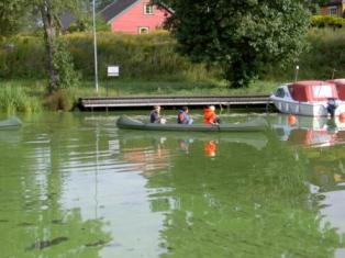
The lake morphology is more complex than in the two Balkan lakes, as Lake Vansjø is divided into two main basins, with a number of islands and bays. The lake is shallow, with a maximum depth of 41 meter and a mean depth of 7 meter. It is one of the richest lakes in Norway in terms of fish diversity, and also hosts a large number of bird species. However. The latter years the blooming of blue green algae has caused severe environmental problems in the lake.
All financing of the research in the Lake Vansjø is derived from other sources then the DRIMON Project, mainly from a project initiated by the local communities around the lake, called “Vannområdeutvalget Morsa”. |
|
|
| |
 |
| |
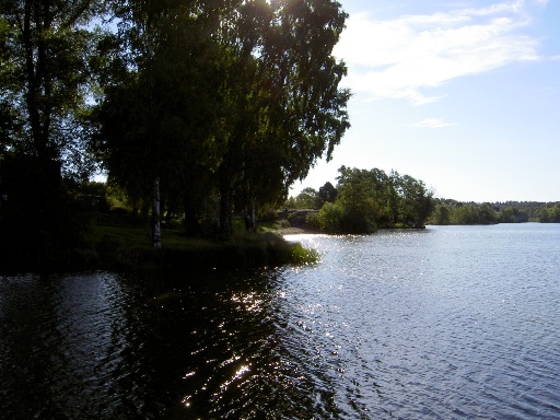
Lake Vansjø in Eastern Norway is a shallow lake with severe algae bloom problems. Photo: E. Skarbøvik |
|
| |
The lakes of the DRIMON Project:
Country(ies) |
Macedonia, Albania, Greece |
Montenegro and Albania |
Norway |
Lake area |
274 km2 |
353-500 km2 |
36 km2 |
Lake max depth |
52 meter |
60 meter |
41 meter |
Lake height |
853 m asl |
5 m asl |
25 m asl |
Lake morphology |
Two basins |
One basin |
Two main basins, several smaller |
Main tributary |
Golema Reka, 231 km2 |
Moraca River |
Hobøl River, 330 km2 |
Main outlet |
Groundwater under the Galichica Mountains to Lake Ohrid |
Buna/Bojana River |
Moss River |
Environmental challenges/pressures |
Agriculture, sewage |
Agriculture, sewage, increasing tourism, industry |
Agriculture, sewage |
Main stakeholder issues |
Farming, fishery, biodiversity, sewage recipient |
Tourism, fishery, sewage recipient, biodiversity, farming |
Farming, leisure activities, drinking water, sewage recipient |
|
| |
Return to the DRIMON main page
_______________________________
Published by Eva Skarbøvik, Bioforsk, 2007
_______________________________
|
| |
|
| |
|
|